Monitoring Carbon Capture
Carbon credits are a crucial tool used to reduce greenhouse gas emissions contributing to climate change. To validate carbon credits and manage carbon at scale, satellites will need to play a larger role because they can provide objective information over huge areas at an affordable price. Hyperspectral data is well suited to more accurate and efficient validation, and could be the key to expanding the carbon credit market worldwide.
Hyperspectral imagery can sometimes infer net change in carbon in certain ecosystems. It can also directly detect greenhouse gas emissions. Here, we describe how the technology could be used by analytics companies to improve carbon credit accountability.
Background
Carbon credits are important because they provide a financial incentive for businesses and individuals to reduce their greenhouse gas emissions. By creating a market for carbon emissions, carbon credits give emitters a way to offset their emissions by funding projects that reduce carbon emissions elsewhere. This can help to reduce the overall level of carbon dioxide in the atmosphere and mitigate the effects of climate change.
In addition, the use of carbon credits allows for the implementation of a cap and trade system, where a government or regulatory body sets a limit on the total amount of carbon that can be emitted. Emitters are then issued a certain number of carbon credits, which they can trade with each other if they need to exceed their limit. This creates a financial incentive for emitters to reduce their own emissions, as they can sell any excess credits they have for a profit. Many countries have instituted some form of cap and trade system.
Carbon offsets can be a useful tool for individuals and businesses looking to reduce their own carbon footprint, but it is important to ensure that the offset projects are legitimate and effective. This can involve verifying the veracity of the claims made by the project developers, and ensuring that the offsets are additional, meaning that the emissions reductions would not have occurred without the funding provided by the offset purchase.
Agricultural Land Management
Agricultural Land Management (ALM) centers around sequestering carbon in the soil and improving farming practices. Some of the most common practices within ALM are as follows:
- Improving planting & harvesting practices through cover crops & rotation
- Reducing soil tillage
- Improving irrigation practices
- Improving grazing practices
- Reducing fertilizer usage
Most of the approved methods of assigning carbon credits in agriculture centers around validating practices and not direct measurement. Direct measurement of carbon using imaging is still not proven. However, validating agricultural practices is a proven correlation to carbon sequestration potential, and hyperspectral imaging will greatly enhance the effectiveness.
Verra, a standards setting organization, provides an extremely detailed methodology for improved ALM here, which details measurement methods & formulae for calculating carbon credits.
Improved Forest Management
Improved Forest Management (IFM) is a number of different approaches that focus on conservation and protection of forests to increase the amount of carbon sequestered over a forest's lifespan. Common practices include:
- Extending rotation age of forests prior to harvesting
- Fire Management
- Rehabilitation of previously logged forests
Similar to ALM, direct measurement of carbon is not yet possible with imaging. However there is strong relationships between forestry practices, vegetation condition, and practice validation that can be directly correlated to carbon credits and sequestration potential.
Verra also has methodologies for improved forest management here.
Wyvern's Solution
Hyperspectral imaging is uniquely suited to validating practice management for ALM and IFM. Because hyperspectral imaging provides more spectral information, additional detail can be extracted from an image to classify a characteristic of interest.
Soil Tillage
A key aspect of ALM carbon credits is the reduction of soil tillage. This can easily be monitored using hyperspectral imagery to detect the presence of lignin and cellulose, and the abscence of healthy plant compounds like chlorophyll and carotenoids. Tilled soil will contain less lignin and cellulose as compared to untilled soil. One such measure is the Lignin Cellulose Absorption Index, which is sensitive to the absorption of lignin and cellulose in the SWIR spectrum [1].

When we apply the LCAI equation to hyperspectral imagery, areas that contain large amounts of dead plant matter (and therefore lots of cellulose & lignin without chlorophyll) will show up as positive values. Healthy vegetation and dirt will present as negative values. This can be observed in the below image, where fields containing large amounts of dead plant material show up as bright green, and healthy fields & dirt present as red & yellow.
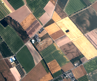
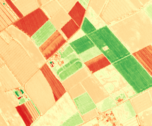
Comparison of pseudo-RGB imagery to LCAI for measuring crop residue
Cover Crops & Plant Growth
Detection of cover crops on fields can easily be accomplished by using hyperspectral indices. Additionally, hyperspectral imagery can be used to easily train classification algorithms to detect what types of cover crops are growing on a field.
A number of hyperspectral indices are well suited for assessing cover crops & crop health. These include RENDVI, and VREI2. RENDVI is useful to detect the presence of healthy vegetation, as non-vegetation is easily filtered out.
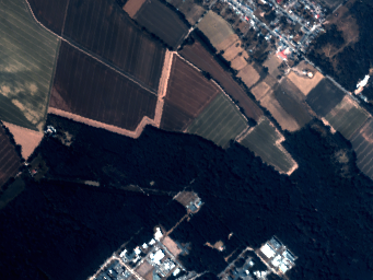
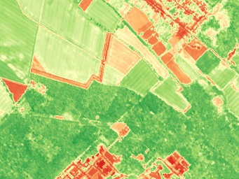
Comparison of 5m Wyvern RGB to 5m Wyvern RENDVI
As we can see above, RENDVI is effective at isolating plant growth from fallow fields and infrastructure. Incorporating the use of RENDVI with a time-series analysis of fields over winter would provide an excellent solution to tracking cover crop usage across large areas.
More Resources
Verra Methodology for Improved Agricultural Land Management
Citations
[1] Daughtry, Craig & Hunt, E.R. & Doraiswamy, Chandraprabha & McMurtrey, J.E.. (2005). Remote Sensing the Spatial Distribution of Crop Residues. Agronomy journal. 97. 10.2134/agronj2003.0291.