Soil & Vegetation Moisture
Measuring soil and vegetation moisture is an important aspect of modern agriculture, as it can affect crop growth and yield, and can also be used to optimize irrigation and fertilization practices. There are several methods that are commonly used to measure soil and vegetation moisture in agriculture, each with its own advantages and disadvantages. High resolution hyperspectral imaging in the SWIR spectrum promises to add another effective tool to the tool box for assessing moisture.
Wyvern's second generation of satellites will be able to deliver high resolution & revisit rates, enabling farmers to effectively track soil moisture during early season planning & seeding, and vegetation moisture throughout the rest of the growing season.
Background
There are two main types of measurements for soil moisture, direct (field sampling), and indirect (sensors, remote sensing, satellites, aerial imagery). Direct measurement methods involve physically extracting a sample of soil and measuring its moisture content directly, while indirect measurement methods use other properties of the soil that are related to soil moisture content, such as soil tension, soil reflectance, or soil temperature, to infer the moisture content.
Direct measurement methods are generally considered to be more accurate than indirect measurement methods, but they can be more time-consuming and expensive to perform. Indirect measurement methods can be used to quickly and cheaply measure soil moisture in large areas of land, but they may not be as accurate as direct measurement methods.
In the case of optical, indirect measurement methods, we use wavelengths from the visible to shortwave infrared parts of the electromagnetic spectrum (700nm to 2200nm). Certain wavelengths in this range will change in response to the moisture content of soils and leaves, which we can then use to indirectly estimate moisture content.
Current Remote Sensing Methods
Remote sensing satellites are widely used to measure soil moisture, as they can cover large areas of land quickly and provide information on the distribution of moisture across an entire field or region. There are several remote sensing satellites that are currently in operation that are specifically designed for soil moisture measurements, including SMOS, SMAP, MODIS, and Sentinel-1.
SMOS (Soil Moisture and Ocean Salinity) is a European Space Agency (ESA) satellite that was launched in 2009. SMOS is equipped with a L-band radiometer that measures the brightness temperature of the surface, which can be used to infer the soil moisture content. SMOS has a spatial resolution of about 35 km, which means that each pixel in the image represents an area of about 35 km x 35 km on the ground.
SMAP (Soil Moisture Active Passive) is a satellite developed by NASA, launched in 2015. It uses a L-band radar and a L-band radiometer to measure soil moisture at a resolution of around 3 km, however its data is heavily affected by the vegetation cover.
MODIS (Moderate Resolution Imaging Spectroradiometer) is a sensor aboard NASA's Terra and Aqua satellites that have been launched in 1999 and 2002 respectively, it provides data with moderate spatial resolution of around 250m and high temporal resolution with daily coverage. MODIS uses infrared and visible wavelengths to estimate surface temperature, which can be used to infer soil moisture content.
Sentinel-1 is a radar imaging satellite that is part of the European Space Agency's Copernicus program. It provides data with high temporal resolution with a revisit time of 6-12 days, but its spatial resolution is quite low, around 20m-100m. Sentinel-1 can provide data even in cloudy conditions, and the radar signal can penetrate through vegetation, making it useful for monitoring soil moisture in vegetated areas.
Although these remote sensing satellites can provide valuable information on soil moisture, they have some downsides. One of the main downsides is that they have low ground sample distance (GSD), which means that each pixel in the image represents a relatively large area on the ground. For example, SMOS has a GSD of about 35 km, which means that each pixel in the image represents an area of about 35 km x 35 km on the ground. This can make it difficult to obtain accurate soil moisture measurements for small areas, such as individual fields or small plots.
Another downside is that the revisit rate is low, which means that a given location is only covered by the satellite every several days. This can make it difficult to observe changes in soil moisture in real-time or over short timescales.
How Wyvern is addressing these challenges
Wyvern will be launching a fleet of innovative satellites that utilize a deployable design by 2030. This allows us to reduce launch costs while still providing high-resolution hyperspectral imaging capabilities in the VNIR and SWIR regions. With the ability to measure various parameters such as vegetation health, water content and stress levels, as well as monitor soil moisture at a high spatial resolution, our technology can provide valuable insights for customers in industries such as agriculture, forestry, and land management. These insights can help optimize crop yields, reduce water usage, and improve overall efficiency in land management.
Measuring Moisture with SWIR
Short wave infrared (SWIR) imagery can be used to measure soil and vegetation moisture by analyzing reflectance in the SWIR wavelength range (900nm to 1700nm). The theory behind this method is based on the fact that the absorption of water within vegetation and soil results in changes to reflectance.
Soil Moisture
Water in the soil absorbs energy in the SWIR wavelength range, which causes a decrease in the reflectance of the soil. This decrease in reflectance can be used to infer the soil moisture content. The amount of the reflectance change is related to the amount of water in the soil and therefore, the soil moisture content can be estimated by measuring the reflectance of the soil in the SWIR wavelength range.
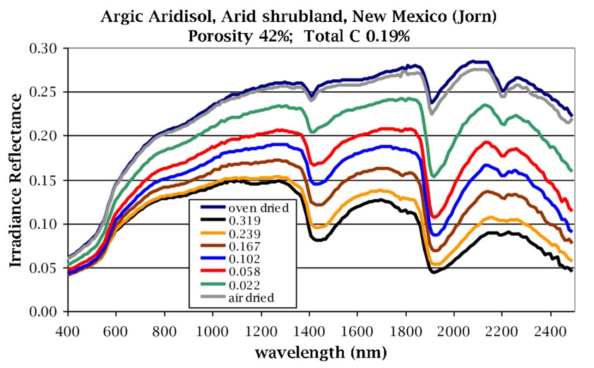
Reflectance of a soil sample with varying degrees of moisture content [1]
The relationship between reflectance and soil moisture content is not linear and can be affected by other soil properties such as soil type, soil texture, soil organic matter and others. Therefore, it is essential to have a good understanding of the soil characteristics of the area being measured and to calibrate the SWIR data with in-situ measurements of soil moisture to obtain accurate soil moisture estimates.
Vegetation Moisture
Vegetation is composed of cellulose, lignin, and other organic compounds that absorb energy in the SWIR wavelength range, the amount of absorption of energy is also related to the amount of water in the vegetation, meaning that the more water present the more energy gets absorbed (and therefore less light is reflected). By measuring the reflectance of vegetation in the SWIR wavelength range, it is possible to infer the vegetation moisture content.
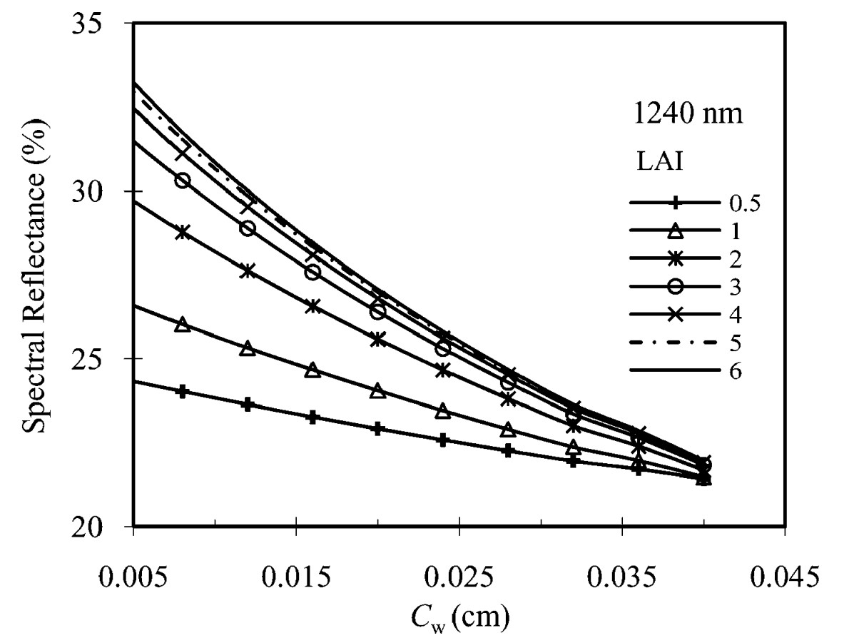
Increased canopy water content (Cw) results in decreased reflectance at 1240nm for multiple leaf area indices (simulated) [2]
However, similar to soil moisture measurements, the relationship between reflectance and vegetation moisture content is not linear and can be affected by other vegetation properties such as species, age, leaf angle, canopy structure, etc. Therefore, it is essential to have a good understanding of the vegetation characteristics of the area being measured, and to calibrate the SWIR data with in-situ measurements of vegetation moisture to obtain accurate vegetation moisture estimates.
Moisture Indices
We can harness the change in reflectance due to water content by isolating parts of the VNIR and SWIR light spectrum that are most sensitive to this change, and developing equations that isolate this change in reflectance from other factors (chlorophyll, different materials, etc). A number of indices have been developed for measuring the water content in soils and vegetation, and include Normalized Difference Water Index (NDWI), Normalized Multi-band Drought Index (NMDI), and Normalized Difference Infrared Index (NDII). More information around index formulas and supporting details is available on our 🌟 Index Library.
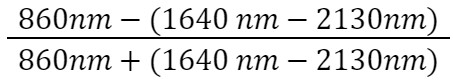
One key index, is the Normalized Multi-band Drought Index developed by Lingli Wang and John J. Qu. It was originally developed for use with MODIS bands, however can be applied to any hyperspectral imagery with similar band centers and band widths. Analysis of the NMDI index showed that it is effective at estimating soil and vegetation moisture in bare soil, weekly vegetated areas, or heavily vegetated areas with a leaf area index of at least 2 [3]. Areas with moderate vegetation cause the signal from the vegetation and soil to become mixed, resulting in inaccurate results. NMDI is designed to be a soil drought measure, or vegetation drought measure; it is not able to be both at the same time. NMDI is also unable to directly measure moisture content of soils accurately.
Below is an example of NMDI applied to a hyperspectral image. Vegetated areas present as blue, whereas bare soil and soil with light vegetation presents as brown. Areas of high and low moisture can be discerned within farmers fields.
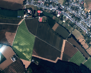
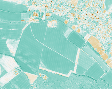
Comparison of RGB imagery to NMDI. Areas of less growth in the centre field can be seen to have similar moisture levels to the rest of the field.
More Resources
Analysis of Soil Moisture Indices
Citations
[1] Philpot, William. (2010). Spectral Reflectance of Wetted Soils. 10.13140/2.1.2306.0169.
[2] Lingli Wang, John J. Qu, Xianjun Hao & Qingping Zhu (2008) Sensitivity studies of the moisture effects on MODIS SWIR reflectance and vegetation water indices, International Journal of Remote Sensing, 29:24, 7065-7075, DOI: 10.1080/01431160802226034
[3] Wang, Lingli & Qu, John. (2007). NMDI: A normalized multi-band drought index for monitoring soil and vegetation moisture with satellite remote sensing. Geophysical Research Letters - GEOPHYS RES LETT. 34. 10.1029/2007GL031021.